GroundWizTM Terrain Map: procedural 3d terrain map
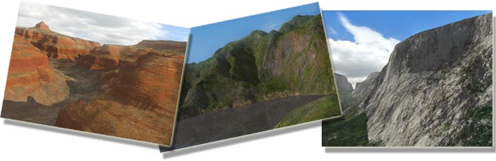
GroundWiz Terrain Map is a procedural 3d terrain map that can be used as a diffuse, bump, displacement, specular, or for that matter any other map type. It uses fractal algorithms to generate terrain textures and mimic real-life terrain. When you are creating terrain maps, transitions between different materials are hard to control with tools that pre-existing applications offer. Typical blending methods of mixing two or more materials don't give realistic results. That is where GroundWiz comes into action. Numerous controls give users the ability to control the look of terrain materials while seamlessly integrating into 3ds Max workflow.
Key Features
- A procedural map that uses layers combined with fractal algorithms to create natural looking terrain maps.
- Infinite detail possible due to a procedural nature of maps. It can produce realistic vistas but also show great detail on close-ups.
- Since it is a 3d map, it is possible to map any shape (caves, hanging rocks, steep canyon walls...) and any type of object (meshes, patches, nurbs...).
- Other than the standard diffuse color and bump map, each layer can also have extra channel information (displacement, specular, reflection, glossiness... etc.) - new since version 1.200.
- Possible to use images and other 3ds Max maps for all the layer channels (diffuse map, bump map, specular map...).
- Can be used with GroundWiz Planter to specify the planting area and quickly create natural looking growth areas (forests, meadows, fields...) - new since version 1.100.
- Compatible with Default Scanline, V-Ray, Brazil & FinalRender Stage-1 renderers.
- GroundWiz also supports mental ray.
- Highly customizable with over 100 parameters exposed: parameters are fully scriptable and animatable.
- Importing Features:
- Importer for Terragen world files, surface files and terrain files (it creates optimized editable mesh).
- Importer for raw binary data (with fully adjustable data types) and importer for 3DEM terrain matrix files
(it creates optimized editable mesh).
User interface
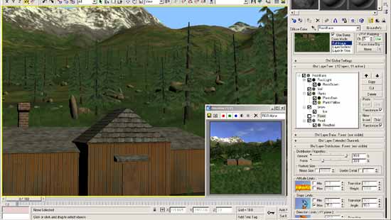
GroundWiz exposes most of its parameters through material editor interface.
Preview: For a better workflow and an easier testing, a preview window is used that will display changes in real-time.
Viewport (new since version 1.100): viewport preview will make it easier to place objects since it shows GroundWiz 3d map in viewport. It gives options for the whole terrain or a focused area. Particularly, focused area viewport mode allows generating texture only for a smaller area to have better resolution.
How it all works
The main building blocks of GroundWiz are layers. Each layer is in essence a map with its own color, bump, displacement, specularity, distribution parameters, etc. To simulate nature, layers have controlled random features that allow us to hide repetitions and create 'natural' ever changing look. A base for these random features is 3D noise function. In GroundWiz, this function (formula) is used to control or modify almost every parameter.
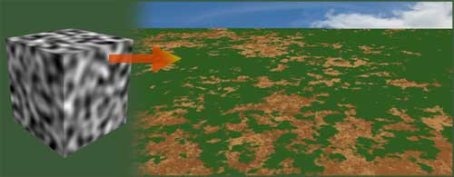
In this example, 3D noise function controls random placement of green layer.
All layers are placed in a tree structure where each layer is affected by its own parameters and also those of its parent. This tree structure allows complex composition of ground to be simulated.
You can use as many layers as necessary: layers for rocks, grass, dirt, gravel, snow, and so on. These layers are put on top of each other just like in real life.
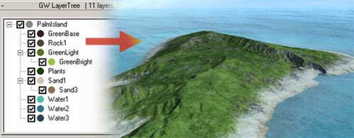
In this case 11 layers are used to create the island terrain.
To learn more about GroundWiz Terrain Map, click here.
|